Mangrove Cover Continues to Rise in India
India's biennial State of Forest Report, 2021
Through cyclones and a pandemic, India's mangrove cover is on an upward trend according to the country's latest review.
Every two years, the Forest Survey of India under the Ministry of Environment, Forest & Climate Change, releases their “India State of Forest Report”, a comprehensive publication of the country’s forests, covering losses and gains in ground cover of all forest types, including mangroves.
India has mangroves along more than 30% of its coastline and almost half of the country’s total mangrove forests are in the South 24 Parganas district of West Bengal, thanks to the Sundarban mangrove ecosystem. The coastal trees help to mitigate damage from extreme storms, like cyclones and monsoons, are important wildlife habitat, store away tons of carbon below ground, and provide resources to communities through enterprises like fishing and beekeeping.
While less detailed than 2019’s report, this year’s report offers an overall positive growth in mangrove coverage with small areas of change across the individual states. Below are featured highlights from the report and details on where gains and losses occurred:

Chapter 1 Introduction
“The information being presented in the latest ISFR 2021 has been derived by way of complete wall-to-wall mapping of the country’s forest cover using remote sensing techniques, sample plot based national forest inventory and special studies carried out at national level.”
“The ISFR is widely used for formulation of policies, planning and management of forests as well as investments affecting country’s forestry sector. The report also provides a significant amount of data which meets India’s reporting requirements to international organizations like Food and Agriculture Organization (FAO) and also for the various conventions and commitments namely United Nations Framework Convention on Climate Change (UNFCCC), Convention on Biological Diversity (CBD) to which India is a signatory.”
Chapter 3 Mangrove Cover
“Important species of Mangrove ecosystems in India include Avicennia officinalis, Rhisophora mucronate, Sonneratia alba, Avicennia alba, Bruguiera cylindrica, Heritiera littoralis, Phoenix paludosa, Morinda citrifolia & Ceriops tagal.”
“Mangroves show conspicuous tone and texture on the satellite images. The Mangrove cover in this assessment has been categorized into Very Dense (canopy density of 70% and above), Moderately Dense (canopy density of 40% and more but less than 70%) and Open categories (canopy density of 10% and more but less than 40%). Table 3.1 [below] presents status of Mangrove cover since 1987 onwards.”

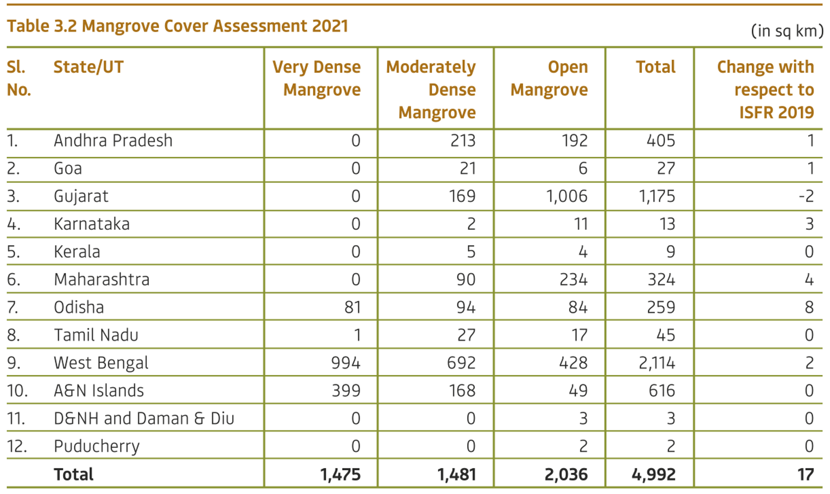
“The current assessment shows that Mangrove cover in the country is 4,992 sq km, which is 0.15% of the country’s total geographical area. Very Dense Mangrove comprises 1,475 sq km (29.55%) of the Mangrove cover; Moderately Dense Mangrove is 1481 sq km (29.67%) while Open Mangroves constitute and area of 2,036 sq km (40.78%). There has been a net increase of 17 sq km in the Mangrove cover of the country as compared to 2019 assessment. The States that show significant gain in Mangrove cover are Odisha (8 sq km) and Maharashtra (4 sq km).
The reason for the increase in Mangrove cover in Odisha, is mainly due to the natural regeneration, plantation activities in suitable land like on the banks of the rivers near the estuary and on intertidal mud-flats associated with the areas that are inundated by sea water on a daily cycle…. In Maharashtra, the increase in Mangrove cover is mainly due to natural regeneration.”
The only state that is shown with measurable loss is Gujarat, which lost 2 sq km compared to 2019 results. Reasoning for loss in Gujarat is not addressed.

You can read all 13 chapters of the Forest Survey report here. A recap of the 2019 report is available here.