Protecting Mexico's Free-Flowing Rivers
It's a conservation approach that benefits mangroves.
WWF-Mexico takes a non-traditional approach to mangrove conservation and restoration: focus on river and watershed health first
One of the last free-flowing rivers in Mexico, the Mezquital River is a 540-km system that traverses the San Pedro watershed, connecting the high sierra of the Durango mountains with the lower coastal plains, finally feeding into Marismas Nacionales, a wetland of international importance that has the largest mangrove area in the Mexican Pacific. This ecosystem is one of three pilot basins (also Rio Conchos and Rio Copalita-Zimatán-Huatulco) that WWF-Mexico used to implement a National Water Reserves Program for Mexico in the mid 2000s, created to maintain constant flows of Mexico’s most important rivers and preserve entire watersheds on a national level. WWF-Mexico works with CONAGUA, Mexico’s National Water Commission, and CONANP, the national public ministry that manages terrestrial protected areas, to help regulate current reserves and support technical aspects of restoration projects.
Though about 76% of total mangrove area lies under some form of conservation status in Mexico, whether federal, state protected area, etc., many of these sites, such as Ramsar sites (wetland sites that have been dictated as important for conservation by the Ramsar Convention), are not regulated by any governing body. Thus the National Water Reserves Program is working with partners and the government to have them included as areas of national protection (see map below). CONANP does not currently include water-based areas in its programs, but WWF-Mexico’s program has changed that for Marismas Nacionales…and will continue to work with the ministry to include other areas, with the help of strong partners in fisheries, freshwater, and forests.
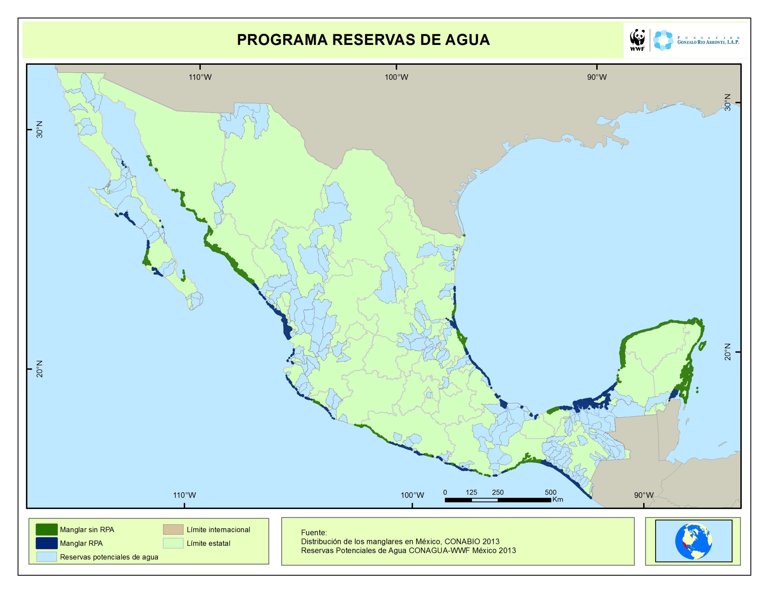
Mangrove Cover in National Water Reserves Program. Green indicates mangrove cover outside of program's reserves. Dark blue denotes mangrove cover within the program's reserves while light blue represents potential new watershed reserves.
The program in Marismas Nacionales and the other pilot basins began work in 2012, and despite constraints of working with many institutions and long complicated processes that take time, successes have been achieved, such as the rejection of a plan to build a dam on the Mezquital that would reduce flow to the lower basin, and incorporating free-flowing rivers and watersheds, and thus mangroves, into protected areas.
Currently, the program aims to establish reserves for 356 watersheds across Mexico (see map below). Some other examples of conservation and restoration projects include working to restore mangroves in the states of Sinaloa and Nayarit (total of 150,000 hectares) to 1970s baseline level, thus restoring an additional 29,000 hectares. Similar preservation and restoration of hydrology is also underway on the other side of the country, in the Usumacinta river basin near the Yucatán Peninsula and in the bioreserve Pantanos de Centla, or “Marshes of Centla” in the Mexican state of Tabasco, which is the most extensive wetland in North America and one of the 15 most important wetlands in the world.
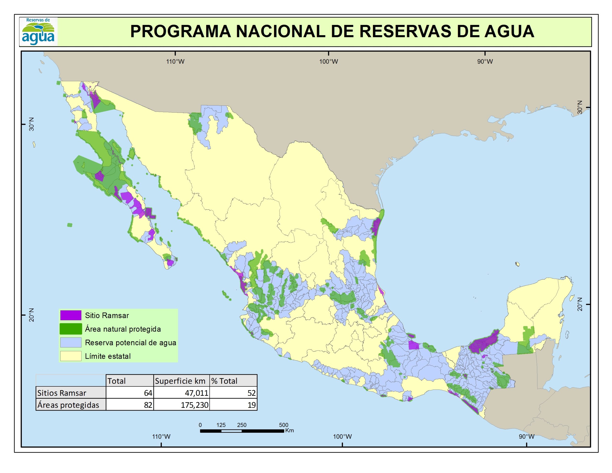
Sites of watershed protection in Mexico. Purple denotes Ramsar sites while green areas are natural protected areas by CONANP. Blue areas are potential watershed sites for protection by the National Water Reserves Program.
Traditionally, mangrove restoration has been viewed in terms of legal protection, planting, and propagules. However, planting often occurs in areas whose ecosystems have been anthropogenically modified, and thus many projects have failed, with survival rates at extremely low percentages. WWF-Mexico and its partners take a different approach; one that’s beginning to be recognized as essential for healthy recovery of mangrove ecosystems. Conserving and restoring the hydroperiod regime of these watersheds is how the National Water Reserves Program is tackling such a massive undertaking of protecting its wetland resources. This method is a very effective and efficient form of restoration activity. The program will continue to connect the dots across Mexico by incorporating river systems, watersheds, and mangroves into conservation and restoration projects, also protecting cultural resources and livelihoods of the people that depend on them.
