New Smartphone App to Collect Information on East Africa’s Mangroves
Collecting the data needed to map mangroves doesn’t need to be a heavy lift. That’s because there’s an app for that, and it’s accessible to everyone with a smartphone.
WWF-Germany, with support from the US Forest Service and USAID, has developed a smartphone app that will enhance and complement field data collection on East Africa mangroves.
The Problem
Many elements can hinder easy access to the field for scientific research. These include security, cost, availability of boats, and connectivity of infrastructure like roads and rivers. In addition, research groups tend to collect data independently from one another, and they lack simple mechanisms to coordinate field expeditions or share and collaborate on data, which would help use limited field research funds more efficiently. Because of these factors, available data are generally so limited in terms of abundance and distribution that it prevents adequate analysis, particularly for the creation and validation of crucial mangrove maps.
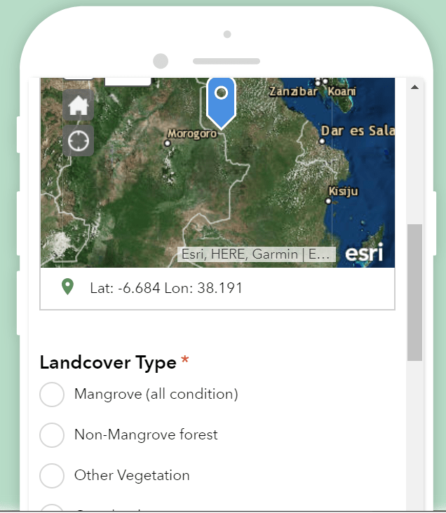
Interface of the East Africa Mangrove Field Data Form.
The Solution
To overcome these obstacles, WWF-Germany has developed a free, easy-to-use smartphone app called East Africa Mangrove Field Data Form that enables anyone to collect vital data on mangrove extent, condition, and species.
The app, translated into Swahili by WWF-Tanzania, send these data to a centralized and accessible database where users can view the data in a map or use it for their own research. It can be opened in a computer browser or on a mobile device, which allows offline data collection. The database can be accessed via WWF’s GLOBIL Online interactive map platform, and there is currently an interactive map in development, which contains mangrove mapping data from NASA’s Carbon Monitoring System, and field data collected by USFS and the University of Dar es Salaam.
What’s Next
The app was first presented to stakeholders at the meeting in Dar es Salaam, November 2017, then refined and customized for the different user groups, and launched in early 2018. The intended audience includes local government, students, and anyone near a mangrove ecosystem who can collect basic information for scientific use.
For more information, please contact Aurélie Shapiro, Remote Sensing Specialist, WWF-Germany.
